Fast next-day shipping provided for every Enterprise-level platform Menu & Tools


High-end Drone solutions for exceptional
* Aerial Mapping and Survey data collection
* Professional Photo and Movie production
* Search and Rescue / Lost Pet Recovery
Mission Ready Drones

FAA Part 107 Certified Operator
* OSHA 10 Certified
* Licensed and Insured
Avata 2

Indoor Real Estate Fly-Through
Transform your property marketing using a seamless, detailed interior walkthrough.
Mavic 4 Pro Mini

Mavic Mini is a Low Observable Drone.
Perfect for Real Estate Filming in tight areas.
4K Video with High-Resolution Photo capabilities
Mavic 4 Pro

Stunning 6K video and High-Resolution Photo
Take your Real Estate presentation to the next level.
* High-resolution Video and Photography
* Aerial Filming
* TV, Motion Picture and Commercial Filming
Matrice 4E

High-Resolution RTK Survey-Grade Mapping
With Real-Time Kinematics, this drone is capable of creating 2D and 3D survey-grade mapping to within 2cm accuracy
* 2D Orthomosaics
* 3D Models
* Point Clouds and Elevation Grids (DSM & DTM)
* RGB Photogrammetry
* Construction site progress monitoring
* Site volumetrics for earth removal estimates
* Elevation grids and slope layout
Matrice 4TD

The Matrice 4TD is the Thermal Inspection King.
* Search and Rescue Day or Night because time is critical
* Pet Recovery day or night
* Law Enforcement assist and Night Tracking
* Cell Tower photo, video, and thermal inspection
* Electrical Grid photo, video, and thermal inspection
* Building Thermal Evaluation
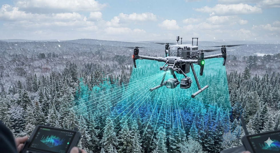
M400
The M400 is our All-Weather, Long-Endurance Platform
* High-Resolution Mapping and Survey
* Thermal Inspections
* LiDAR imaging for forest and large- scale land deliverables
* SAR Day or Night all-weather
* High-Resolution 4K video, 45 MP photo

Services
Real Estate

Standard Photo Package
$295.00
15 Edited High-Resolution Photos.
Single Location
Advanced Package
$600.00
10 Edited High-Resolution Photos
30-Second Video Compilation
Gold Package
$725.00
15 Edited High-Resolution Images
2-Minute Video Compilation
Fly-Through
$825.00
15 edited High-Resolution Images
2-Minute Video with FPV tour through your listing
Services
Aerial Mapping and Survey
Aerial Photography and Video
* Panoramic View Photo (Digital or Large format print)
* Construction Time-Lapse
* Property Insurance Photo and Video
* Events and Special Occasions
Detailed Services
Call for Quote
High-Resolution GNSS and NTRIP guided Drones for all your Mapping and Survey needs.
* RTK Capable Base Stations and Drones.
* 2D and 3D Orthomosaic maps:
Geometrically corrected, high-resolution single raster images (GeoTIFF) used for accurate site measurement and base mapping
* 3D Point Clouds:
Dense collections of georeferenced X, Y, Z coordinates (LAS/LAZ files) representing surface geometry for structural and terrain analysis
* 3D Textured Meshes:
3D surface reconstructions (OBJ/GLB files) providing realistic visual models for asset inspection and stakeholder presentations
* Digital Surface Models (DSM):
Elevation grids capturing the top of all objects on the surface, including trees and buildings.
* Digital Terrain Models (DTM):
"Bare-earth" elevation models filtered to remove vegetation and structures, used for grading and drainage design.
* Contour Lines:
Vector files (DXF/SHP) depicting elevation intervals ready for direct import into CAD software
* LiDAR scanning to estimate forest yield, biomass, and timber volume
How LiDAR Yield Estimation Works
Point Clouds: Laser pulses reflect off leaves, branches, and the ground to create a 3D digital map called a point cloud.
Height and Density Metrics: Computers measure canopy height, crown diameter, and vegetation cover from the scan data.
Allometric Models: Foresters combine these LiDAR measurements with sample field plots using regression models to calculate total volume, basal area, and biomass across the entire forest
Advantages Over Traditional Methods
Full Coverage: Aerial scans map 100% of the forest area instead of relying on small 2% to 5% manual field sample plots.
Speed and Scale: Drones or airplanes scan large tracts of land in hours, reducing labor costs for timber assessments.
Digital Twins: Scans create a permanent 3D digital model of the stand to track growth over time


Customized Photography or video captured for whatever may be required. Aerial platforms up to 6K.
Ground-based Cinema Cameras up to 12K. Edited on Hollywood platforms.


NOTICE: Informational data only. This is an aerial remote sensing product and NOT a certified land survey. Property lines, contours, and volumetric calculations are approximations. Do not use for legal boundary establishment or final engineering designs without independent verification by a licensed Professional Land Surveyor (PLS).

Lost Pet
Time is critical in lost pet situations. The sooner we start looking, the better the chances of finding your lost pet.
Weather also plays a factor. Cloud cover and mild temps help with thermal returns. Let us help reunite you with your lost friend.
The M400 can search for almost an hour without the need for battery changes. That means more time searching, increasing recovery chances.
